How the islands’ climate is changing: Winds and tides
Published 1:30 am Saturday, April 18, 2026
By Russel Barsh
Kwiaht
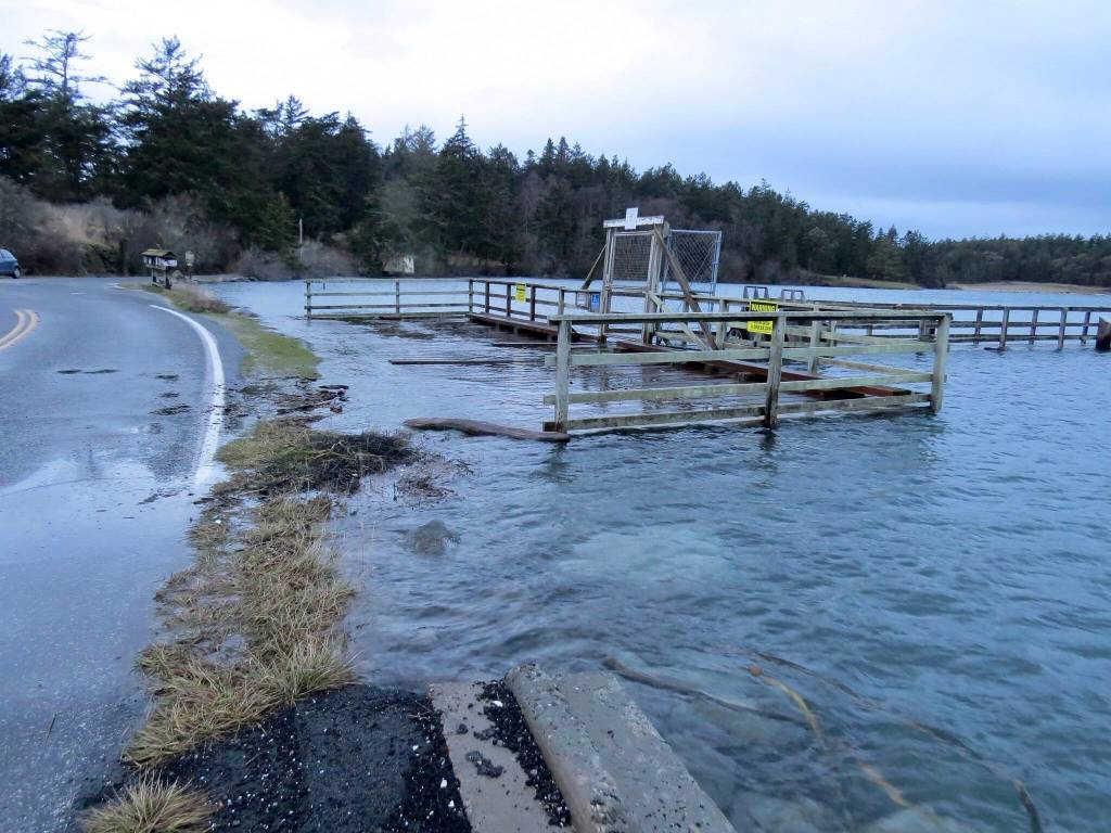
Although sea-level rise is a serious long-term challenge, with increases of up to 6 feet likely by the end of the 21st century, a more immediate issue here in the San Juan Islands is an increase in the frequency and strength of windstorms, which is already measurable. Kwiaht researchers have studied the interaction of tides and wind at Fisherman Bay, Lopez Island, since 2010, and have found that Force 6 winds (25-31 mph) add as much as two feet to “king tides.”
Force 6 winds were felt almost weekly along island shores this past winter. In addition, storms often blew from the west-southwest, rather than northeast, shifting the parts of the shoreline that bore the brunt of flooding and erosion.
The effect of increasing storminess on island shorelines is equivalent to the consensus forecast of SLR to 2050. In other words, 2050 is now in the islands. And wind-driven waves are much more damaging to coastal habitats and human structures than mere flooding. Waves do not merely soak; they beat and batter. A 1.5-foot increase in waves represents a greater threat to our coasts than a 1.5-foot rise in sea level, that is, in tides.
Increased storminess is also associated with Extreme Precipitation Events, or EPE: severe sudden downpours that dump rainwater faster than it can infiltrate soils naturally, and indeed, faster than storm sewers and diversion works can route water safely into reservoirs or seas. As a result, roads become floodways, and low-lying homes and shoreline structures are vulnerable to being washed away. What we used to call the “Pineapple Express” — a strong flow of warm, wet weather from the Pacific Ocean — is now called an atmospheric river. The change in terminology is not superficial. In a heated, more turbulent atmosphere, wet Pacific flows can persist for days to weeks, producing freight trains of successive windy downpours.
The total annual deposit of rainwater is not necessarily any greater than it was 25 years ago; however, it is arriving in larger buckets over a shorter span of time. What this means, as a practical matter, is not just a stormier winter but a longer summer drought, with implications for agriculture as well as fire management. Growers can respond to lengthier dry seasons by using more irrigation water, or ultimately by switching to more drought-tolerant crops.
However, EPEs reduce aquifer infiltration and thereby reduce our stock of groundwater. The islands’ drinking water supplies were already flagged as a challenge by state agencies in the 1970s. Most of our wells tap into fossil water trapped in very old, deep sands and fissures, many of them below contemporary sea level. As we draw down these deposits (and as sea levels rise), saltwater intrusion is increasingly likely. Thus, we cannot long respond to a droughty future by drawing down our limited freshwater deposits faster. Rain catchment and recycling water are attractive alternatives, but EPEs can easily overwhelm existing catchment structures and tend to reduce their efficiency. New catchment architecture is required to address this problem.
By saturating the islands’ thin soils, moreover, EPEs increase the likelihood that wind will topple our larger, older trees and denude hillslopes. In turn, blow-downs and washouts further increase flooding and reduce infiltration and aquifer recharge. Historically, the islands have had very few natural ignitions (lightning) causing wildfires. Storms, wind and flooding were responsible for periodically opening up our forest canopies. It is ironic that contemporary island planners are preoccupied with wildfire risk, when there is a comparable if not greater risk from an increasing likelihood of forests blowing down rather than burning down as storminess intensifies.
The combined impacts of these changes include not only loss of intertidal habitats such as sandy beaches and eelgrass meadows, blasting fish and fish eggs out of streams, shifting the species composition of our forests and farms, but also the damaging of the roads and power lines that follow miles of San Juan County shorelines, interrupting ferry service (and food delivery), running down well water reserves faster, increasing energy costs, and challenging our ability to produce more of our own food, water and energy.
While planning and preparing for several feet of sea-level rise by 2100 is a good idea, storminess is happening now. As scientists, we are concerned that island-specific threats from climate change are not yet concretely addressed in local planning or public works.