In-depth weather data for farmers
Published 1:30 am Sunday, November 20, 2022
Bu Kathryn Wheeler, Journal contributor.
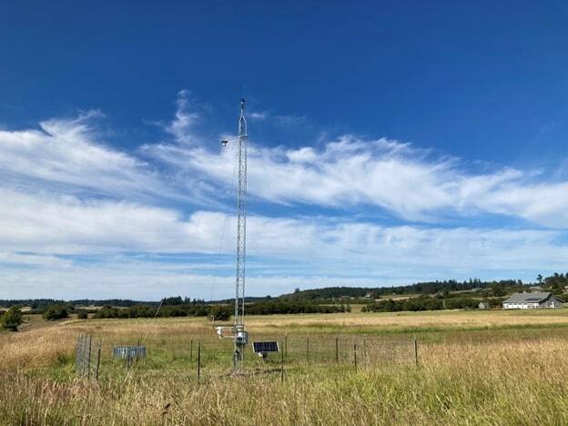
In June of this year, Friday Harbor erected its first weather station that gathers weather data specifically for agricultural use. The station is part of the University of Washington’s state-wide weather monitoring program, called the Ag Weather Net, which seeks to provide in-depth weather data to farmers on its publicly available website. The data is in-depth, including soil moisture levels, soil temperature, and a log of precipitation and expected rainfall.
WSU’s Ag Weather Net program began as an initiative in central Washington in 2002 with the goal of helping Washington farmers “make timely and economically sensible decisions” around the irrigation of their crops based on predicted precipitation, according to their website. WSU now has 160 weather stations across the state and a “Decision Aid System.” DAS provides information to fruit growers that use models to estimate oncoming insects, diseases, and other potentially harmful crop threats and provides resources on best management practices and pesticide use.
While San Juan County has other weather stations providing weather forecasts to residents, this station focuses on providing more in-depth data designed for farmers in a largely agricultural-based community. Prior to this, the closest of its kind was in Anacortes and therefore unable to provide accurate weather data to the islands.
When WSU presented the idea to the county in 2020, the San Juan County Preservation Trust answered the call. The SJPT owns the most land in the county (3,000 acres on San Juan Island alone). While primarily a conservation-based organization the SJPT also works to bring sustainable agriculture onto these vast swaths of conservation land as a way to ensure their ongoing relevance to the community and future preservation. In regards to whether to host the tower, it was a “pretty logical choice” said Dean Dougherty, the Director of Stewardship who has worked for the SJPT for 20 years.
After spending two years looking for a suitable, non-obtrusive land, the SJPT got permission to use the Phelps Preserve in the San Juan Valley, which dips low enough that the thin 30-foot-tall weather station, which is powered by solar panels, doesn’t stand out or obstruct any neighbors’ views.
While the impact of the station on local farmers is too early to tell, Brook Brower, the Director of WSU extension in San Juan County and a leader on the project is excited about the potential. It is “another tool for the agricultural community…and gives us insight into what’s going on in our environment and to be able to respond,” he said.
In a place that is becoming more noticeably impacted by drought and more variable weather, “it helps inform the conversation around the impact of climate change on production,” said Brower.
Dougherty echoed this sentiment and believes the station is another way to support his goal of adopting best management practices for agricultural lands and finding the appropriate balance between conservation and agriculture.
As a tool that provides insight, as expressed by both Brower and Dougherty, the weather station may be the critical piece that local farmers need to adapt to a rapidly changing future.