What takes 14 years of painstaking planning but just six months to accomplish?
The realignment and replacement of a 1.3-mile stretch of county road that passes through a portion of National Park Service property, on Mount Finlayson, no less, that’s what.
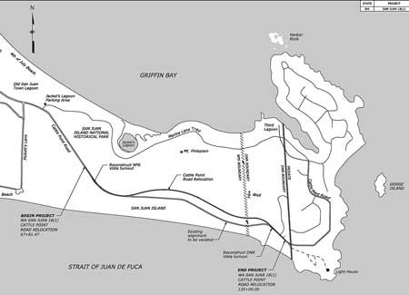
Construction, surveying and the breaking of ground on the much-debated, long-awaited realignment of Cattle Point Road is slated to begin the week of April 13. Drivers headed to and from San Juan Island’s south end should expect 15-minute delays in the early morning hours and up to 30 minutes throughout the day, Monday through Friday, once construction begins.
The $6.2 million road-realignment project is expected to be completed by mid-October, according to San Juan Island National Historical Park Superintendent Lee Taylor.
“We realize there will be some disruption of daily life for islanders and some inconvenience for visitors,” Taylor said in a press release. “But the pay-off will be a safe, as well as scenic, right-of-way through the park that will ensure our neighbors continue to have unimpeded access to their homes and visitors will be able to enjoy public lands far into the future.”
Threatened from below
Persistent erosion along a high-bank, weather-worn bluff and the threat of road collapse prompted San Juan County officials to begin planning in 2001 for relocating that stretch of roadway. Though erosion varies at different points along that 1.27-mile stretch of road, each year roughly 1.5 to 2 feet of the bluff tumbles to the waterfront far below, on average, according to Shannon Wilbur, project engineer for the county Public Works department.
A distance of only 30 feet separate the edge of the bluff and roadway at the closest point, Wilbur said.
“It does vary from year to year but sometimes the amount of bluff that’s lost to erosion can be dramatic,” she said. “In the last couple of years it hasn’t been a whole lot.”
At its south end, Cattle Point Road connects the neighborhoods of Cape San Juan and Cattle Point Estates to the rest of the island, and it provides access to a historic lighthouse and a popular viewpoint that looks out over the intense tidal action in Cattle Pass and to the Olympic Mountain Range beyond.
The County Council recently awarded the $6.2 million project contract to Bellingham-based Strider Construction. A $5.5 million federal grant, secured in June 2012 out of $42 million awarded that year by the Federal Lands Access Program, will pay for the bulk of the relocation project.
New roadway nearer to ridge-line trail
Starting at Pickett’s Lane, the stretch of road that now winds along the base of Mount Finlayson will be moved 300 feet uphill from its current location. The right-of-way will pass about 150 feet below the 1.5-mile ridge trail traversing its summit. The network of hiking trails that weave through Jakle’s Lagoon and Mount Finlayson will be unaffected by the realignment and remain open during construction, Taylor said.
Construction will proceed in accordance with the project’s final environmental impact statement. The National Park Service is taking measures to minimize impacts on the rare island marble butterfly, including a pre-construction survey and removal of host plants to reduce the likelihood of butterflies laying eggs in the construction zone. The existing roadbed will be re-vegetated with native species as part of a post-construction reclamation project and as spelled out by the EIS.
“It’s going to be re-contoured and re-seeded, and after a while you won’t even know the road was there,” Wilbur said.
The upcoming realignment is expected to prolong the life of the roadway by more than 70 years and allow for an upgrade of utilities that serve the south end of the island, Wilbur added.
The agencies partnering in project: San Juan Island National Historical Park, Western Federal Lands Highway Division, Washington state Department of Natural Resources and San Juan County Public Works. The final EIS can be viewed at the county Public Works website.