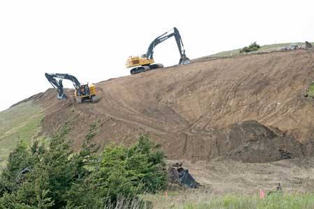
The relocation of Cattle Point Road began in earnest last week, as road construction crews carved out a corridor on a steep slope on the south side of Mount Finlayson, signaling the start of a new stretch of roadway that will soon rise up and over the west-facing landmark at the southern tip of San Juan Island.
The $6.2 million road replacement and realignment project will no doubt dominate the landscape at the south end of the National Parks Service’s American Camp and is anticipated to be complete by mid-October, if not sooner. Though modest in scope, as construction projects go—the length of road to be realigned measures roughly 1.3 miles—it’s the largest project on San Juan Island National Historical Park property in recent memory and the biggest for Parks Superintendent Lee Taylor.
“It’s a pretty big project and this is my first superintendency,” Taylor said. “So, I haven’t had to oversee a project like this before. So far, so good.”
The project contract was awarded to Bellingham-based Strider Construction by the San Juan County Council, and the bulk of its cost will be paid for by a $5.5 million federal grant, secured by the county in June 2012, out of $42 million awarded that year for capital projects nationwide by the Federal Lands Access Program.
San Juan County Council, and the bulk of its cost will be paid for by a $5.5 million federal grant, secured by the county in June 2012, out of $42 million awarded that year for capital projects nationwide by the Federal Lands Access Program.
At its south end, Cattle Point Road connects the neighborhoods of Cape San Juan and Cattle Point Estates to other areas of the island, the only roadway leading to and from the south end, and it provides access to a historic lighthouse and a popular viewpoint that overlooks the intense tidal action in Cattle Pass and to the Olympic Mountain Range beyond.
Starting at the north side of the bluff, at Pickett’s Lane, the stretch of road that now winds along the base of Mount Finlayson will be moved 300 feet uphill from its current location. The right-of-way will pass about 150 feet below the 1.5-mile ridge trail that traverses its summit. The network of hiking trails that weave through Jakle’s Lagoon and Mount Finlayson will be unaffected by the roads’ eventual realignment and remain open during construction, according to NPS.
The Parks Service primary role during construction will be to watch for any uncovering of archeological pieces and for the endangered Island Marble Butterfly or disturbance of the plants that sustain it. The Parks Service will also have a key role to play in the eventual rejuvenating of existing area of roadway once it’s removed.
Persistent erosion along the weather-worn bluff and threat of a potential road collapse prompted San Juan County officials to begin planning for relocating that stretch of roadway back in 2001.
Though erosion varies at different points along that 1.3-mile length of roadway, each year roughly 1.5 to 2 feet of the bluff tumbles to the waterfront far below, on average, according to Shannon Wilbur, project engineer for the county Public Works department.
Drivers headed to and from San Juan Island’s south end should expect 15-minute delays in the early morning hours and up to 30 minutes throughout the day, Monday through Friday, once construction begins.
According to a recently released report by the National Park Service, a total of 268,946 people visited San Juan Island National Historical Park in 2014. That number included hikers, bicyclists, beach walkers and site-seers, and no fewer than 33,000 people visited the Visitor’s Center at American Camp.
The road’s realignment is expected to prolong the life of the roadway by more than 70 years and also allow for an upgrade of the many utilities that lie within the road corridor and that serve the south end of the island, according to Wilbur.