
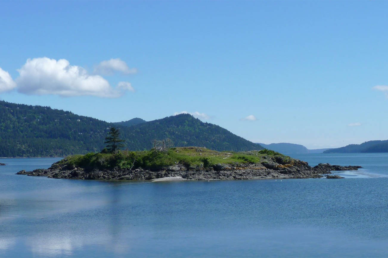
Camping on Indian Island could be an option in the future, but it’s a long shot according to Marcia deChadenedes.
Bureau of Land Management released its San Juan Islands National Monument Proposed Resource Management Plan and Final Environmental Impact Statement on Nov. 22, which included the small island off the shore of Eastsound as part of a 274-acre area that could potentially allow camping by permit in the future. The document is available online at https://go.usa.gov/xRphc where you’ll find appendices and a Frequently Asked Questions document.
“My expectations are that it is unlikely that it will become available for that once it’s gone through the NEPA review,” deChadenedes, who is the manager of the San Juan Islands National Monument, said. “It’s a really significant area. There are all kinds of tribal history there. … It’s really unlikely that it would happen.”
According to deChadenedes, if the BLM chose an option wherein Indian Island could potentially allow camping someday, before permitting could even begin, the island would first have to go through a National Environmental Policy Act (NEPA) process.
“We need to do a cultural survey on those landscapes to determine where the sensitive resources are,” deChadenedes said. “Once identified, those areas are not included as being accessible.”
The RMP/EIS also addressed this wherein it said, “When developing the permitting system during plan implementation, the BLM will consult with tribes and conduct cultural resource surveys of the areas designated for dispersed camping. As part of this process, the BLM will develop protective permit stipulations to address potential impacts to sensitive cultural and ecological resources.”
The 317-page document, along with its 26 appendices, contains management options ranging from no action to a complete shutdown of public access to the entire monument. Also included in the plan are options regarding hiking, boating, hunting and more. Over the last five years, the BLM has worked with islanders to create the RMP/EIS document.
“Islanders have formally been involved throughout the process to make suggestions and comments on outreach materials, scoping meetings to identify issues to be addressed in the planning process, recreation charrettes in the monument, and numerous gatherings during the draft plan comment period,” a press release from the BLM said. “The Bureau of Land Management also engaged 17 separate local, state and federal government entities, and 12 tribal governments for their review and recommendations.”
The document notes that while dispersed camping occurs very infrequently if camping needs aren’t met outside of the monument those requests could increase.
Here is how each option would handle camping in the monument:
No Action Alternative: With no action, 214 acres would remain designated site camping; 304 acres would remain dispersed camping; and 503 acres closed to camping.
Proposed: Under the BLM’s preferred plan, 214 acres of designated camping sites would remain open; 274 acres dispersed camping by permit only would be chosen; and 533 acres would be closed to camping. The more than 500 acres of closure includes a continuation of the current camping prohibition at Chadwick Hill, Iceberg Point, Point Colville, and Watmough Bay (total of 503 acres) as well as a new prohibition on this activity on 30 Monument acres currently open to this use.
Alt. A: The most limiting of the options in the plan is Alternative A which would allow for 0 acres of designated camping; 0 acres of dispersed; a total of 1,021 acres — the entire monument — closed to camping. Under Alternative A, only authorized research, educational, cultural and spiritual activities would be allowed in the monument. Recreational use, including camping, would be prohibited unless for uses authorized by the BLM.
Alt. B: In this alternative, 214 acres of designated camping would remain open; 726 acres would allow dispersed by permit only; and 78 acres would be closed to camping entirely. This would include a continued camping ban at Watmough Bay, as well as a new camping prohibition at Freeman Island, Indian Island, Skull Island, Victim Island and Category A and B Rocks.
Alt. C: In Alternative C, 214 acres would be open for designated camping; 0 acres for dispersed; and 807 closed. Camping would still be prohibited at Chadwick Hill, Iceberg Point, Point Colville and Watmough Bay, as well as a new prohibition on 302 Monument acres that are currently open to camping.
Alt. D: In the final alternative, 436 acres of designated camping would be available; 535 acres of dispersed; and 50 acres would be closed to camping. Under this alternative, the BLM would add an additional 221 acres of designated camping to the monument, which would approximately double the current monument acres open to designated site camping. This alternative would include a continuation of the current camping prohibition at Watmough Bay, and add new prohibition at Indian Island, Twin Rocks, Victim Island and Category B Rocks.
Protest period
The press release noted that approximately 1,200 comments were received during the draft plan review period. The release also added that the Proposed RMP is not a final decision. For 30 days following the release of the document, citizens are asked to submit any protests they may have to the proposals. Protests must be received by Dec. 22.
“This is an opportunity for people to — a lot of people put in their comments about that and asked for it to be closed for camping and asked for it to only be open for science and education,” deChadenedes said. “We encourage people if they want to take the question off the table to go ahead and protest.”
All protests must be in writing and filed with the BLM director, either as a hard copy or electronically via the BLM’s ePlanning website. Detailed instructions for filing a protest are available online at www.blm.gov/programs/planning-and-nepa/public-participation/filing-a-plan-protest.
To file a protest electronically, visit https://go.usa.gov/xRphc and click the ‘Submit Protest’ button to the right of the Final EIS document. Following a resolution of any protests and the completion of the consistency review by the Governor of Washington, the Approved RMP and ROD will be made available electronically on the BLM’s ePlanning website https://go.usa.gov/xRphc.
You can also mail hard copy protests to: Director (210), Attn: Protest Coordinator, P.O. Box 71383, Washington, D.C. 20024-1383. Or for Overnight Delivery: Director (210), Attn: Protest Coordinator, 20 M Street SE, Room 2134LM. Washington, D.C. 20003
deChadenedes praised the passionate people of Orcas Island and encouraged them to submit their concerns in the form of the document protest.
“There is a really strong advocacy group, a really strong citizen science group over there on Orcas,” deChadenedes said. “We really appreciate all the work that they’ve done out there.”
