With a 45-pound pack strapped to his back, Bob Anderson is trudging back and forth in the upper elevations of Mount Rainier this week.
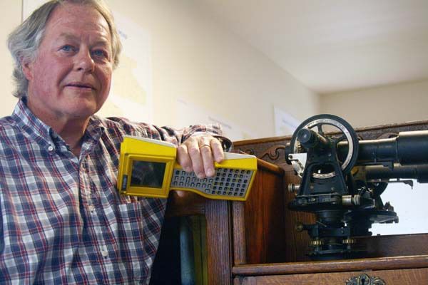
He’s the intrepid leader of a survey team that’s using the latest GPS equipment to measure the height and gravitational tug of Washington state’s tallest peak.
It’s the third time that Anderson, owner of San Juan Island-based Star Surveying and a world-class mountain climber, has led the once-every-decade expedition of hand-picked professionals. And as before, the information that they collect will be used to remeasure the mountain’s height and to build a storehouse of data concerning its density.
When it comes to equipment, Anderson said a lot has changed since 1988 when he first climbed Mount Rainier. Equipment is lighter, more compact and much more sophisticated.
“We’re just wired,” he said. “Our ability to collect and store data — and to broadcast it — is about 1,000-fold of what it was 20 years ago. If we had our Blackberry with us, we could probably watch ESPN up at base camp (10,000 feet).”
The global-positioning satellite (GPS) system was still in its infancy some 20 years ago. Still, data collected from the 1988 expedition proved more precise than the “old school” of triangulation, and the mountain gained about a foot in elevation, at 14,411, once the numbers were crunched. Measurements collected by the 1999 team turned out to be within a half-inch of the previous mark.
Anderson intends to make the most out of this expedition because, he said, at age 58, it will probably be his last. Getting in condition for such a climb, he said, isn’t as easy or as satisfying as it once was.
“Getting up at 4:30 a.m., putting a 40-pound pack on my back and walking up Mount Finlayson is getting old.”
For Anderson, the lure of the expedition is professional and personal. He’s scaled many of the tallest peaks in the western hemisphere, including Mount McKinley (20,320 feet) and Aconcaqua in the Andes (22,841 feet), and conducted surveys of an assortment of areas that, for most, would be off the beaten path, including Hells Canyon, the North Cascades and the entire country of Bhutan.
And while scaling Mount Rainier may be “old hat,” Anderson said each climb has its own risk. He’s got battle scars to prove it. He nearly lost a hand after falling into a crevasse in the Cascades about 10 years ago. And several years earlier, Anderson’s wife, Angela, also a world-class climber, died in an avalanche while skiing the upper elevations of an Alaskan mountain.
For a climb leader, Anderson said the top safety concerns are staying clear of falling objects and guarding against exhaustion of any member of the 10-person team, which is hand-picked from the ranks of the Land Surveyors’ Association of Washington. And though keeping close tabs on the team is a must, Anderson said nothing surpasses the camaraderie that comes from pushing the envelope with fellow professionals and besting the elements at 10,000-plus feet.
“It becomes a lasting friendship when you’re sharing a tent at 10,000 feet, and in 40-knot winds, with the temperature at minus 5 degrees,” he said. “But there’s nothing like coming down from the summit after spending some time there. It’s one of those timeless spaces you find yourself in every now and then.”