Connection concerns | Pear Point Road residents question plans for the connector road
Published 8:12 am Monday, September 11, 2017
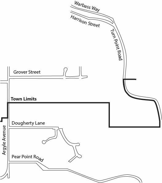
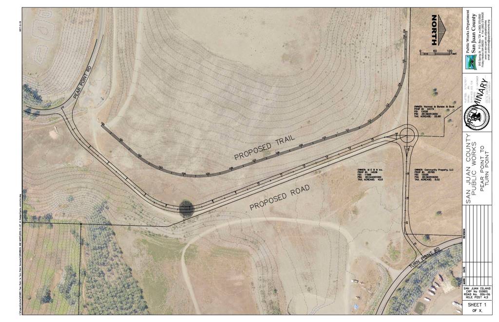


The construction of the street, known as the “connector road” by islanders, has been discussed, off and on, over the last decade. The street would create a shortcut from Turn Point Road to Pear Point Road, which already connects and circles the eastern side of San Juan Island.
“I had heard pieces of it,” said Councilman Bill Watson about the project when he moved to San Juan in 2006. “Now, since I’ve gotten involved with the county, it makes sense to me.”
Watson ran his inaugural San Juan County Council campaign, last year, on completing the 10-year-old project, which was delayed due to insufficient funds. County and Town of Friday Harbor officials attest it will offset additional traffic from nearby planned housing developments, among other improvements.
Now, with the funds allocated by a council vote in April and the right of ways being finalized, it would appear plans are coming to fruition.
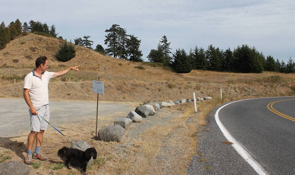
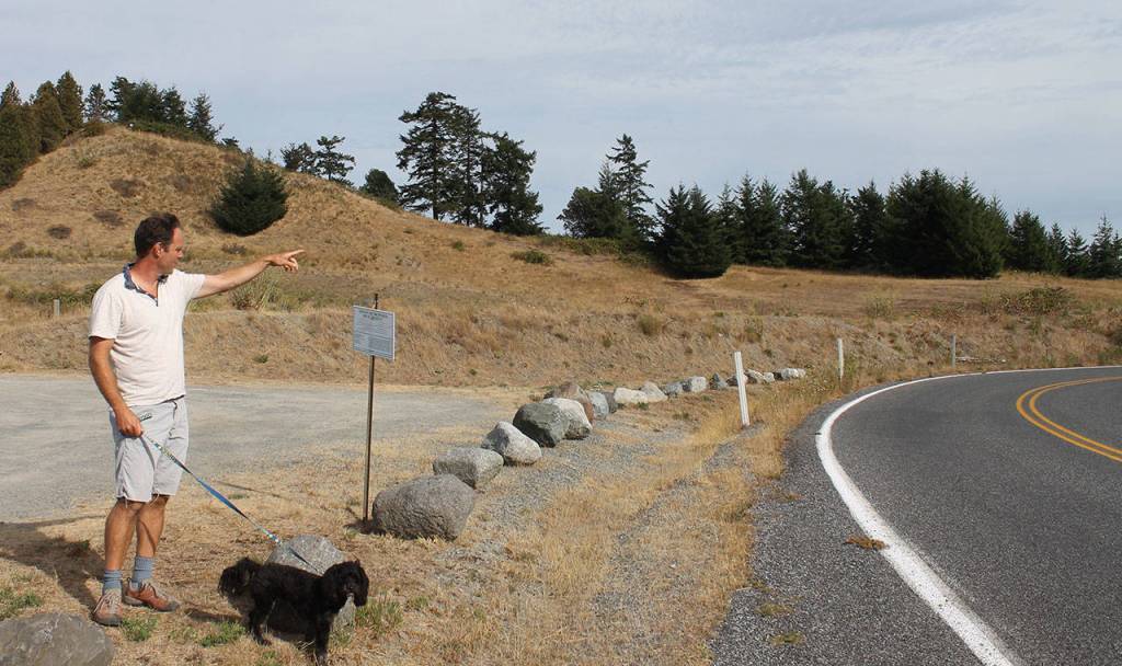
Not if it’s up to Gib Black. He and five of his Pear Point Road neighbors halted construction with a July 11 appeal, requesting a more in-depth environmental review of the project.
The connector road, Black affirms, should not be built. Instead, the existing town street of Grover, located about four miles northwest of Pear Point, should extend to Turn Point.
Black’s plan
Grover Street should be built out, said Black, because a 2010 county engineer’s report recommends it. The report — based on a study by an engineering company commissioned by the county — states it’s the county’s most affordable road option for the planned developments.
Black said he believes there is no plan to extend Grover Street because a con argument in the report states a housing development owner disapproves of it.
“Can someone tell me why that makes sense?” asked Black. “Perhaps it’s because of the developers’ fear that their homes/lots will be worth less if there is traffic coming through their new neighborhood.”
In a signed agreement, the Town of Friday Harbor staff also requested the developer create an “emergency access only” road between Grover and Turn Point, even if another connector road is created for public use. This, said Black, supports Grover as the quickest route.
History
Most San Juan County residents have heard of the connector road, but details of the plans — allegedly discussed as early as the 1990s — can often be hazy. Black and Watson acknowledge the original agreement to build the road was verbal — leaving a weak paper trail — but Watson attests this is an accepted municipality practice.
According to Town of Friday Harbor Administrator Duncan Wilson, the agreement is simple: town officials helped to quell the county’s affordable housing needs by annexing land, so the county council promised a connector road to ease traffic increases.
A 2011 letter from the town council to the county council states the county council asked the town to annex 46 acres of property near Pear Point Road to build affordable housing around 2008.
The original property owner kept 31 of those acres for a market-rate development, while 15 acres was sold to the San Juan Community Home Trust to build affordable housing, according to Town of Friday Harbor Land Use Administrator Mike Bertrand.
Due to the different zoning regulations, moving the development from the county to the town allowed more houses to be built per acreage. Plus, the developments could use town water, instead of individual wells. Also, a large, shared septic system was added by the town, continued Bertrand.
To restrict the number of buildable houses, town officials made an agreement with the developers: build 30 market-rate homes and 30 affordable houses now, and the other roughly 200 once county staff built the connector road. This would reduce an influx of new traffic heading into town and by the ferry lanes. It would also divert traffic from the narrow, one-way street of Warbass Way, said Bertrand.
Unlike many current town and county elected officials and employees, who were not involved in the original connector road decisions, Bertrand was there.
He recalls several public hearings around 2009 about the location of the road, including one where attendees placed stickers over their preferred connection to Turn Point Road.
Dougherty Lane, Bertrand said, was thought to be too steep to build out; Grover, he said, was decided to be too close to the elementary school for increased traffic; so the creation of a new connector road, eventually won.
“This is 10-year-old news,” said Wilson. “All of the decisions on the project have already been made.”
Appeal
Black doesn’t agree with the project’s roughly 10-year-old decisions; he says they need to be re-examined.
For instance, although the connector road is being built to divert traffic off of Warbass Way, a 2008 traffic study states the new road wouldn’t help.
According to the study — which was created by an engineering company on the county’s behalf — the housing developments would attract drivers to the intersection of Warbass and Harrison, “thereby counteracting the impacts from the [connector road’s] diverted trips.”
The connector road would, however, divert fuel trucks from Warbass, assures Watson, who states this is the main reason to keep traffic off of the narrow road. Fuel and other trucks arrive on the island from barges at Turn Point’s Shipyard Cove Marina.
The project also includes a turnaround and a weight-limit sign on Warbass, heading into town, said Wilson. That way, trucks leaving the marina can reverse and use the connector road to get to town instead of using Warbass.
Yet, since Pear Point and Turn Point already connect without the shortcut, the road isn’t even necessary if there is a turnaround, said Black.
However, diverting fuel truck traffic to this route would create the same safety concerns Black has about Pear Point’s increased traffic from the connector road, attests Watson. Black’s environmental review appeal questions why these effects of increased traffic on Pear Point pedestrians and cyclists have not been considered.
Watson admits that there are many county roads that need more walkability, including Pear Point. He said he is committed to adding a way to increase street safety to the county’s roadway project list next year.
“One of [the county’s] road objectives is to address non-motorized vehicles better,” said Watson, “but that could be said about the whole Turn Point-Pear Point loop, which is a favorite bicycling and walking loop. That is true today without the connector road.”
The July appeal also states the review does not account for the sight distance needed in the Pear Point and connector road intersection. Sight distance measures the length of a roadway visible to a driver.
April emails with the former county public works director and Black state sight distance was measured using cars, while Black suggests it should be calculated using trucks, due to the diverted Shipyard Cove traffic.
Colin Huntemer, who has served as county engineer for about a year, said there is ample sight distance to stop a car or truck on the road, but there could be slowed traffic from cars entering the intersection.
“We would never design an intersection where there was insufficient stopping sight distance,” said Huntemer.
Future
The appeal’s hearing, which Black said has yet to be scheduled, will ultimately decide the continuation of the road, but to Watson, Bertrand and Wilson, there is nothing left to determine.
“There are a lot of smokescreen issues,” said Wilson, “but if you just take a deep breath and look at this thing, you will see the simplicity of it; the town just wants the county to fulfill their commitment.”
To Watson, the road is on the county’s long list of overdue projects, which is now preventing additional housing to be built on an island with a housing shortage.
“Government tends to operate slowly,” said Watson. “The county has delayed too many activities for too long and we’re paying the price today.”