
Submitted by the National Transportation Safety Board.
The National Transportation Safety Board and the U.S. Navy will recover the wreckage of the DHC-3 Turbine Otter that crashed on September 4 off Whidbey Island, Washington, the NTSB said Friday.
The investigation and preparations for recovery are ongoing. The main recovery effort to raise the wreckage is expected to begin on Sept. 26.
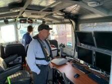
The U.S. Navy will use the work class remotely operated vehicle (ROV) Deep Drone 8000, a barge and a crane to recover the wreckage from the seafloor. Once the barge is outfitted and in place, it will be a 24/7 operation. The crane will lift the aircraft wreckage pieces. The ROV will work on the seafloor collecting smaller pieces of wreckage into baskets and connecting the wreckage to the crane to be lifted.
NTSB also released today the preliminary report for the investigation. The report contains facts only; the NTSB will determine the probable cause of the crash at the end of the investigation.
According to the preliminary report, the aircraft departed from Friday Harbor, Washington, around 2:50 p.m. Pacific time, with a destination of Renton Municipal Airport. At 3:09 p.m., the aircraft impacted the water and sank. The pilot and nine passengers were fatally injured.
The airplane was operating under Part 135 of FAA regulations, which governs the operation of business and charter flights. The accident occurred during the pilot’s second trip of the day. Each trip involved multiple flight legs.
Witnesses near the accident site reported the airplane was in level flight before it entered a slight climb, then pitched down in a near-vertical descent. Several witnesses described the airplane “spinning,” “rotating” or “spiraling” during portions of the descent.
NTSB coordinated with the Washington Department of Fish and Wildlife, the National Oceanic and Atmospheric Administration’s (NOAA) Navigation Response Team and the University of Washington’s Applied Physics Laboratory to locate the wreckage in Mutiny Bay. A sonar survey located the main wreckage and debris field at a depth of approximately 190 feet.
Information contained in the report is preliminary and subject to change as the investigation progresses. The preliminary report details facts uncovered during the initial on-scene investigation and does not include analysis or a probable cause for the accident. Probable cause will be determined at the end of the investigation, which could take between 12-24 months to complete. No conclusions about the cause of the accident should be made based on the information contained in the preliminary report.
Preliminary Report:
On Sept. 4 at 1509 Pacific daylight time, a de Havilland DHC-3, N725TH, was substantially damaged when it impacted Mutiny Bay near Freeland, Washington, and sank. The pilot and 9 passengers were fatally injured. The airplane was operated as a Title 14 Code of Federal Regulations (CFR) Part 135 scheduled flight. The US Coast Guard and good Samaritans responded to the accident site.
The accident occurred during the pilot’s second trip of the day; each trip involved multiple flight legs. A review of Federal Aviation Administration (FAA) tracking data revealed that the accident flight departed from Friday Harbor Seaplane Base (W33), Friday Harbor, Washington, about 1450 with a destination of Renton Municipal Airport (RNT), Renton, Washington. The track data indicated the airplane flew a southerly heading before turning south-southeast. The en route altitude was between 650 and 975 ft above mean sea level (msl), and the groundspeed was between 115 and 125 knots. At 1508:43 the altitude increased to 1,125 ft, and the groundspeed reduced to 109 knots. At 1508:49, the altitude decreased to 875 ft and the groundspeed reduced to 100 knots. The tracking data ended at 1508:51, at an altitude of 700 ft and groundspeed of 55 knots.
Witnesses near the accident site reported that the airplane was in level flight before it entered a slight climb, then pitched down in a near-vertical descent. The airplane continued in a nose low, near-vertical descent until it impacted water in Mutiny Bay. Several witnesses described the airplane as “spinning,” “rotating,” or “spiraling” during portions of the steep descent. One witness reported hearing the engine/propeller noise and noted that he did not hear any “pitch change” in the noise.
The pilot began working for the operator in 2013 and was one of two pilots who flew the DHC 3, which he began flying in 2017. He had accrued a total of 4,686 flight hours as of May 31, 2022. His total flight hours in the DHC-3 have not yet been determined. He received training in emergency drills and procedures in May 2022, and an aircraft competency check in June 2021.
The airplane’s most recent 100-hour inspection was performed on September 1, 2022. Included at that time were recurring inspections required by Airworthiness Directives (AD) 83- 04-05 (control column lower assembly) and 2011-18-11 (elevator control tabs). A left-hand rudder retract cable was replaced during the 100-hour inspection. The previous 100-hr inspection was performed on August 16, 2022, which also included the recurring AD inspections noted above. At that time, the horizontal stabilizer hinge bolts, a right-hand engine ignitor, and a left-hand float locker latch were replaced.
The airplane was not equipped nor was it required to be equipped with a flight data recorder or cockpit voice recorder. A King 560 Enhanced Ground Proximity Warning System was installed, which can retain some parametric flight data; however, the unit was not crash-protected. Some floating debris was recovered by local authorities and good Samaritans who responded to the accident site. This included three 6-ft sections of aluminum honeycomb panels used for flooring in the airplane, a seat cushion and seat belt, and small sections of foam, consistent with a modification made to the landing floats.
The NTSB structure’s group chairman went on board vessels provided by the Washington Department of Fish and Wildlife, the National Oceanic and Atmospheric Administration (NOAA) and the University of Washington to collect data using varying types of sonar equipment.
A sonar survey of the accident area located the main wreckage and debris field at a depth of about 190 ft.
At 1515, the automated weather observing station at Jefferson County International Airport (0S9), located 10 nautical miles northwest of the accident site, reported wind from 310° at 10 knots, visibility 10 statute miles, few clouds at 4,000 ft and 7,500 ft, broken clouds at 9,000 ft, temperature 20°C, dew point 14°C, and an altimeter setting of 30.02 inches of mercury. Additionally, pilots flying in the vicinity of the accident area reported turbulence and a scattered cloud layer at 2,300 ft.
The US Navy will be assisting the NTSB with the wreckage recovery, and examination will begin once the wreckage is recovered.
Aircraft and Owner/Operator Information
Aircraft Make: DEHAVILLAND
Registration: N725TH Model/Series: DHC-3
Aircraft Category: Airplane Amateur Built
Operator: Operating Certificate(s) Held
Operator Designator Code: Commuter air carrier (135)
Meteorological Information and Flight Plan
Conditions at Accident Site: VMC Condition of Light: Day Observation Facility, Elevation: K0S9 Observation Time: 15:15 Local Distance from Accident Site: 10 Nautical Miles Temperature/Dew Point: 20°C /14°C Lowest Cloud Condition: Few / 4000 ft AGL Wind Speed/Gusts, Direction: 10 knots / , 310° Lowest Ceiling: Broken / 9000 ft AGL Visibility: 10 miles Altimeter Setting: 30.02 inches Hg Type of Flight Plan Filed: Company VFR Departure Point: Friday Harbor, WA (W33) Destination: Renton, WA (RNT)
Wreckage and Impact Information
Crew Injuries: 1 Fatal Aircraft Damage: Substantial Passenger Injuries: 9 Fatal Aircraft Fire: Unknown Ground Injuries: N/A Aircraft Explosion: Unknown
Total Injuries: 10 Fatal Latitude, Longitude:
Administrative Information
Investigator In Charge (IIC): Brazy, Douglass
Additional Participating Persons: Matt Rigsby; FAA/AVP; Washington, DC Note:
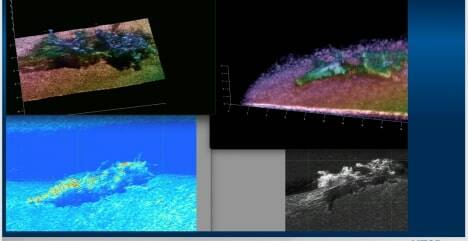
Contributed photo from the NTSB – Images from University of Washington Applied Physics Lab Multi-Sensor Towbody (MuST) – including 3D processed data of main wreckage.
